History of Tripura

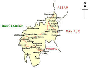
Origin : The origin of the name of Tripura is still a matter of controversy among historians and researchers. According to the 'Rajmala", Tripura's celebrated court chronicle, an ancient king named 'Tripur' ruled over the territorial domain known as 'Tripura' and the name of the kingdom was derived from his name. A school of historians,however, challenge this story and identify 'Tripur' as an imaginary and ahistorical character. Many researchers explain the name 'Tripura' from its etymological origin: the word 'Tripura' is a compound of two separate words, 'Tui' (water) + 'Pra' (near) which in totality means 'near water'. The geographical location of the state with it's close proximity to the vast water resources of Eastern Bengal (present Bangladesh) coupled with the generic identity of the state's original inhabitants as 'Tipra' or 'Twipra' apparently justify this explanation of the state's name. Except 'Rajmala' there is no authentic document to base Tripura's history upon even though a plethora of archaeological and numismatic evidences have helped reconstruct the history of the state over the past five centuries. Historical Background of Tripura: Tripura is a hilly & land locked State endowed with vast green forest and located in the North-East part of India. The State has total area of 10,492-sq. km. and is stretched in between 22°56' and 24°32' North Latitudes and 91°09' & 92°20' Longitudes. The State merged with the Indian Union on October 15,1949 after independence of the Country as “C” Category State and became an Union Territory on 1July, 1963 and attained State-hood on 21 January, 1972. The State has a long boarder with Bangladesh with 856 km and has also common boarder with the neighboring States of Assam & Mizoram. The state has 4- Districts, 15-Sub-Divisions, 40-Development Blocks and has also one Autonomous District Council (ADC). The prominent hill ranges are Jampui, Sakhantang, Longtharai, Atharamura, Baramura , Deotamura, Belkum & Kalajhari. The important forest products include Sal, Teak, Gamai, Gurjan, and Champa. The Bamboo is available in the State abundantly, and is traditionally being used for multi-purposes by the tribal people. The Gomati, Howrah, Dhalai, Muhuri, Feni, Juri are the major rivers which swell in monsoons but they become shallow during the rest of the year The State is located in the Bio-geographic zone of 9B-North-East Hills and possesses an extremely rich bio-diversity. The local flora and fauna bear a very close affinity and resemblance with floral and faunal components of Indo-Malayan and Indo-Chinese sub-regions. There are 379- species of trees, 320- shrubs, 581- herbs, 165- climbers, 16- climbing shrubs, 35- ferns, 45- epiphytes and 4- parasites. Rare plants of Tripura have been put to 18 numbers. There are 266 species of medicinal plants in the State (68- trees, 39- shrubs, 71- herbs and 88- climbers). There are 90 mammal species in Tripura and in the aquatic ecosystem 47 species of fish have been found. As per last Census of Wild Life conducted in 1989, there are 39 numbers of Leopard, 182 numbers of Elephant and 92 numbers of Bison in the State. According to the provisional estimate of Census- 2001, the Population of Tripura stands at 31,91,168 registering a population density of 304 per sq. km. The estimated birth rate in the state is 17 per thousand population which is much lower than All India figure of 20.7 per thousand population in 1999. The prevailing death rate of 5.7 per thousand population & infant mortality rate of 42 per thousand population in the State are also much lower than All India level of 8.7 and 70, respectively, in 1999. There are 19- Sub tribes among the Scheduled tribes in the state with their own cultural identity, namely i) Tripuri ii) Reang iii) Jamatia iv) Chakma v) Lusai vi) Mog vii) Garo viii) Kuki ix) Chaimal x) Uchai xi) Halam xii)Khasia xiii) Bhutia xiv) Kunda xv) Orang xvi) Lepcha xvii) Santal xviii)Bhil xix) Noatia. The ST population was 8,53,345 (30.95%) in 1991- Census. The demography of Scheduled Caste in the State is not confined to ‘Paras’ or ‘Bastis’ like other parts of the country. The social distance between the scheduled castes and other communities is minimum. The total SC population in the State was 4,51,116 (16.36%) in 1991- Census. Tripura lives in villages. Almost 84.6% of State’s populations with 66.81% Below Poverty Line (BPL) families are living in rural areas. Upliftment of rural poor as well as improvement in the quality of life of the economically weaker section of the society has been one of the basic objectives of development Planning in the State. In order to achieve the goal, the State has successfully been implementing the Rural Development & Poverty Alleviation Programmes in the State to ensure minimum wage and also to acquire assets & income in 2000-2001. The Gross State Domestic Product (GSDP) at Current Prices increased from Rs. 1777.23 crore in 1993-94 to Rs. 3814.18 crore in 1998-99 and further to Rs. 4524.42 crore in 2000-2001 (Q). The Net State Domestic Product (NSDP) commonly known as State Income increased from Rs. 1619.27 crore in 1993-94 to Rs. 3472.59 crore in 1998-99 and further to Rs. 4182.83 crore in 2000-2001 (Q). The Primary Sector contributes to 34.19%, Secondary Sector 14.01% & Tertiary Sector 51.80% of Net State Domestic Product at current prices as per quick estimate of 2000-2001 (Q). The Per Capita income at current prices of the State was Rs. 5350/- in 1993-94, which rose to Rs. 9611/- in 1998-99 and further rose to Rs. 10930/- in 2000-2001 (Q). On the other hand, Per Capita National Income at current prices in 1993-94 was Rs. 7698/-, which rose to Rs. 15841/- in 1999-2000. Ref: http://www.tripurainfo.com/abouttripura/trip_history.shtml


Comments